
Since it's such a rainy day, I thought it might be interesting to take a brief look at Placentia's flood-y history.
Tropical Storm Chantal was a bit of anomaly, as floods go. Up until the 1990's, it wasn't rain that would flood us, it was tide, and it wasn't Dunville or Ship Harbour or Southeast or Point Verde that was at risk, it was the flats of Placentia itself.
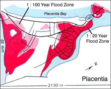
Check out this flood risk map, from the Water Resources Atlas of Newfoundland. As you can see, naturally most of Placentia floods approximately once every 20 years; the lighter pink floods once every 100 years. It seems only the area from the Star Hall through to CONA is in the clear. The historic district of town seems to be most at risk.
Unfortunately, Old Placentia's prognosis is not good, from an environmental point of view. According to a Memorial University-run website, although the embankment facing the open sea and the seawall all along the Orcan protects us now, "it will be increasingly difficult to protect Placentia from floods" "if one of the effects of global warming is a rise in sea-level."
I guess we'll deal with it as we always have done. Placentia has had some terrible floods over the years, and in future entries I'll delve further into this aspect of our history. It's part of the geographical nature of the town --- we're Newfoundland's version of Venice or New Orleans.
Friday, November 9, 2007
Placentia's Floodplain
![]()
Subscribe to:
Post Comments (Atom)


No comments:
Post a Comment